I've been on some pretty nice walks in the Washington, D.C. area, especially here in Virginia, but today's hike was the nicest by far. Walking a round-trip total of 6.8 miles (10.9 kilometers) in 4¾ hours, I started out from Riverbend Park in Fairfax County, made my way along the Potomac River down to the Great Falls and beyond, before turning inland and then making my back along the same route. The skies were clear and the weather chilly (high 30's F) but not uncomfortable. The fact I was facing the sun much of the time on the trails provides a convenient excuse for why my photos are nowhere close to being as stunning as the actual scenery, but I'll remember this outing for a long time to come.

The waters of the Potomac were deceptively tranquil as I set out along the Potomac Heritage National Scenic Trail.

This massive rock outcropping was apparently once sitting at the bottom of the ocean - it's 500 million years old, formed when the African continent slammed into the North American continent, lifting the seabed in the process. Or you can believe in edenic gardens. The choice is yours.

This small aqueduct dam marks the obvious southern limit for boaters on the Potomac. From this point, only a moron or someone with suicidal tendencies would want to go into the river.

This seemingly languid stretch of river is actually the remnants of a canal that was designed to skirt the Great Falls. Railroads and high maintenance costs combined to put the canals out of business.

The current was starting to get swifter as I approached the visitor center at Great Falls National Park.


Inside the visitor center could be seen displays such as the above rock, covered in petroglyphs, and exhibits on a time when, thanks to a trolley that ran from Georgetown in Washington during the early years of the 20th century, a visit to the Great Falls was a popular day trip. Outside the visitor center are three overlooks providing scenic vistas of the falls.

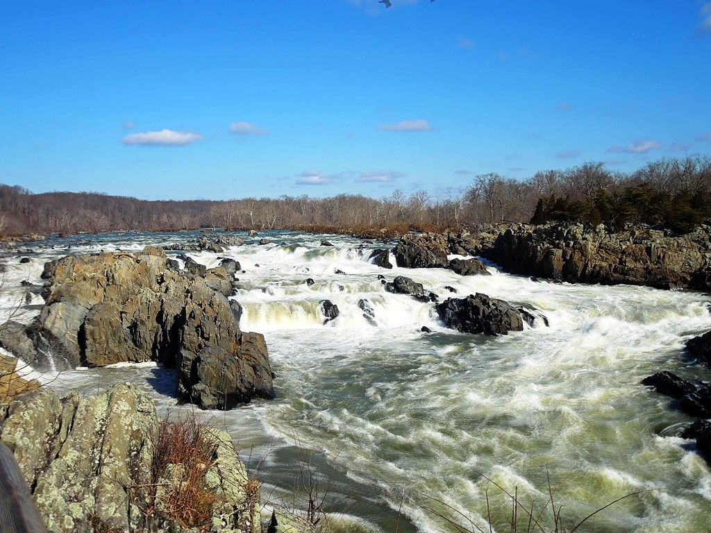
Overlook 1
Overlook 2

Overlook 3

Yours truly poses with a post showing various high-water marks from Potomac flooding. The highest was in 1936, which you can just make out at the top of the photo.

I continued past the Great Falls as I followed the Potomac. The bridge pictured above connects Olmsted Island with the Maryland side of the river. Amber, Pamela and I visited here back in September, when we took a boat ride along the C&O Canal and took a look at the waterfalls.

Mather Gorge, named after the first director of the National Park Service


For the most part, all that can be seen of the Patowmack Canal are the cut in the landscape and the remains of the locks.

Looking down to the point where boats went back into the Potomac from the canal

There were moments when I could forget that the year is 2013, and that I'm living in a country of 315 million people.

River Trail came down from the rocky ledges above to briefly make contact with the Potomac at river-level at Sandy Landing.

The trail soon started rising again, and eventually made its way inland, but not before providing final glimpses of the Potomac.


Here being Virginia, there were plenty of ruins to be seen in the woods. What the sign doesn't inform us of is that Matildaville was founded by "Lighthorse" Henry Lee, Revolutionary War officer, governor of Virginia and father of a traitor to the Union.

Eventually, the trail made its way back to the visitor center and beyond, as I followed the River Trail back to where I started. On the way back I passed by more remnants of the Great Falls Skirting Canal.

The local waterfowl are no doubt impervious to the winter chill

Passing by the aqueduct boundary again. In the background is Conn Island.

For the last leg of the return journey, I detoured into the woods for a quiet walk among the trees before finding my way back to the car. This afternoon's hike was one of the finest I've been on, and the river scenery brought back memories of driving along the Columbia River separating Oregon and Washington. Only this time I was on foot, a much preferable mode of travel.
No comments:
Post a Comment